
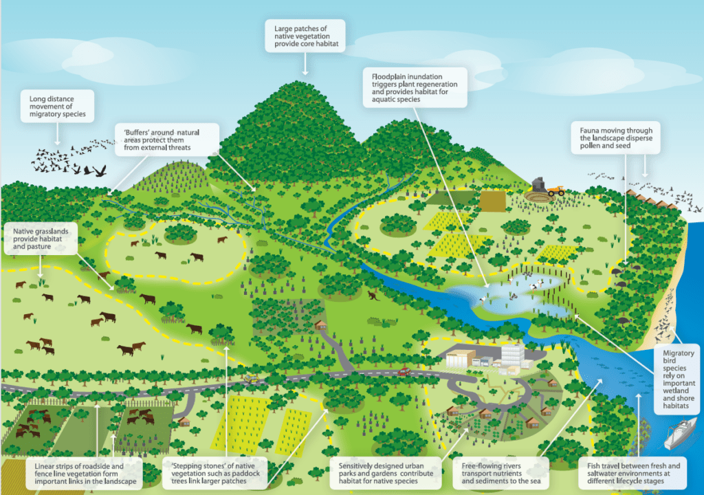
Mending a fragmented landscape
Since the mid-1970s, conservationists, planners and land managers have been directing their attention to the formation of regional biolinks as an intuitively appealing way of slowing the decline of biodiversity in Australia, a continent that has lost over 40% of its forests since colonisation – 70 to 80% in states like Victoria.
Also known as greenways, green belts, shelterbelts and wildlife corridors, the biolink concept resonates because it is easy to understand.
In his highly influential book, Linkages in the Landscape, La Trobe University conservation researcher, Andrew F Bennett, notes the appeal of biolinks as “a visible solution to a visible problem – habitat fragmentation is generally a strikingly-obvious process. Equally, habitat corridors are a visible sign of efforts to ‘mend’ the fragmented landscape (‘bandages for a wounded natural landscape’ – Soulé and Gilpin 1991).”
He also notes that the ability to establish biolinks at different scales gives local communities the feeling they can ‘do something about’ the damage in their local environment and see visible results.
Do biolinks actually work?
The rapid uptake of biolink projects around the world initially outpaced scientific understanding and data collection. Questions were raised about their effectiveness, particularly given the scarcity of conservation resources. Multiple studies were conducted looking at the key domains of:
- Landscape connectivity – the physical connections between habitats across a landscape.
- Habitat connectivity – connections between patches of habitat (‘stepping stones’) suitable for specific species.
- Ecological connectivity – the function of ecosystems across space and time.
- Evolutionary connectivity – allowing populations to interact naturally, breed and strengthen genetic diversity.
In 2010, the first meta-analysis was published. It showed that corridors increase migration between habitat patches by as much as 50%. Ten years later, a second analysis was done to solve questions raised in the first analysis. It found that, although not all corridors worked as planned, overall corridors effectively increase species movement, fitness and richness. This further translated into an increase in community biodiversity.
Macro (large scale) biolinks
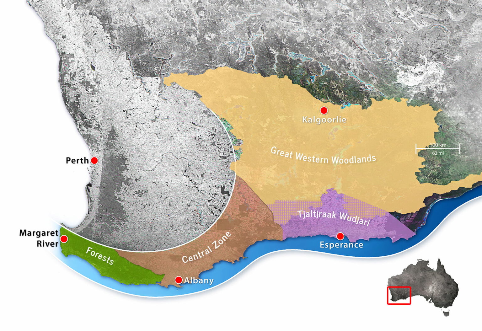
Beginning in the early 2000s, up to a dozen large-scale biolinks were proposed or established in Australia, one of the earliest being the Gondwana Link project in south-western Australia. Conceived by a small group of conservationists in 2000, the program now coordinates dozens of separate conservation projects along a 1,000 km corridor from the forests of Margaret River to the semi-arid woodlands and Mallee country bordering the Nullarbor Plain.
In 2005, Greening Australia began shaping up its Habitat 141 project; a 50-year collective response to habitat fragmentation and climate change along the 141st longitude stretching from the coast of South Australia, along the Victorian border, and up to the rugged rangelands of New South Wales.
Noting the success of these and other projects and how they might be connected to the National Reserve System (a network of more than 10,000 Commonwealth, state and territory protected areas) in 2012, the Australian Government published a National Wildlife Corridors Plan. Information on that plan is now difficult to find online. The program appears to have been folded into one of the most ambitious initiatives of all – the Great Eastern Ranges biolink.
This impressive program seeks to conserve and manage a 3,600 km ‘continental lifeline’ of habitats, landscapes and people from the Grampians in western Victoria, along the Great Divide and Eastern Escarpment of New South Wales and the Australian Capital Territory, to the wet tropics and remote Cape York Peninsula in Queensland’s far northeast.
Over 250 regional, state and national organisations have chosen to align their activities with the GER vision. Among them is the Biolinks Alliance, which performs a unique role as a capacity and partnership-building organisation consisting of 18 member Landcare networks working mostly in Central Victoria.
The missing link – community-based conservation
Australian National University researcher Carina Wyborn has been studying conservation connectivity since the early 2000s. Many of the themes she discusses in her publications discuss the challenges of collaboration.
“Without people working together, connectivity initiatives will go nowhere (Lovett et al. 2008), thus collaboration and community-based conservation are central.
“Centred in an ethic of place, community-based conservation is underpinned by the premise that local populations have a greater interest in and knowledge of local contexts … further, “by placing these local contributions within a larger picture (e.g large-scale programs), gives conservation on private land greater purpose.”
Paddock-scale connections
For decades, individual landholders have been working with organisations like Landcare to restore and protect pockets of habitat on private land. This work is critical, given that over 60% of all land in Australia is privately owned or managed (farms, pastoral leases and mines) and that 70% to 90% of inadequately protected wildlife is found on private land.
However, it has sometimes been difficult to see these activities within a broader vision.
Given their commitments to sustainability and better environmental management, many councils are stepping up to fill critical gaps, offering incentives to landholders and practical tools such as maps. A great example of this is Cardina Shire Council’s interactive map, which shows what has been done and what opportunities there are for improvement.
BioDiversity Legacy is also working with landholders and organisations across Australia, like Land Covenantors Victoria and Prom Coast Ecolink, to promote the connection of private landholdings and consider how they too can be tied into the vision we all share – protecting and connecting land for conservation and threatened species.